 |
| The Distribution of Wealth, 1870 |
 |
| Ranking of States by Income, Debt, Literacy, etc, 1880 |
|
| The Distribution of Wealth, 1870 |
|
| Ranking of States by Income, Debt, Literacy, etc, 1880 |
1 (1.000000): The taxes upon expense, therefore, which fall chiefly upon that of the superior ranks of people, upon the smaller portion of the annual produce, are likely to be much less productive than either those which fall indifferently upon the expense of all ranks, or even those which fall chiefly upon that of the inferior ranks, than either those which fall indifferently upon the whole annual produce, or those which fall chiefly upon the larger portion of it.
2 (0.961065): I shall endeavour to give the best account I can, first, of those taxes which, it is intended should fall upon rent; secondly, of those which, it is intended should fall upon profit; thirdly, of those which, it is intended should fall upon wages; and fourthly, of those which, it is intended should fall indifferently upon all those three different sources of private revenue.
3 (0.765899): From the end of the first to the beginning of the second Carthaginian war, the armies of Carthage were continually in the field, and employed under three great generals, who succeeded one another in the command; Amilcar, his son-in-law Asdrubal, and his son Annibal: first in chastising their own rebellious slaves, afterwards in subduing the revolted nations of Africa; and lastly, in conquering the great kingdom of Spain.
4 (0.708201): You must pay, too, for the tax upon the salt, upon the soap, and upon the candles which those workmen consume while employed in your service; and for the tax upon the leather, which the saltmaker, the soap-maker, and the candle-maker consume, while employed in their service.
...No, nothing about pins, but still pretty interesting.


 “CropScape delivers data visualization tools directly into the hands of the agricultural community without the need for specialized expertise, GIS software or high-end computers,” said Mark Harris, NASS Research and Development Division director. “This information can be used for addressing issues related to agricultural sustainability, land cover monitoring, biodiversity and extreme events such as flooding, drought and hail storm assessment.”
 A colleague and I are doing some work on refugees and ran across this excellent vizualization of UNHCR data here. This is how they describe it:
Since 1950, the United Nations High Commissioner for Refugees is mandated with the coordination of aid and assistance for refugees worldwide. According to its self-description, its primary purpose is to safeguard the rights and well-being of refugees. Over 6,000 people in more than 110 countries work for the UNHCR. Founded in 1951 as a means to assist the more than one million people who were still uprooted after World War II, the agency's mandate covered about 10 million refugees in 2009. This visualization attempts to give a comprehensive overview of the phenomenon of flight and expulsion, an ongoing issue of global scale and extreme complexity.
Based on the annual UNHCR Refugee Report, the application allows views from different perspectives on the extensive dataset, highlighting different aspects. The idea for this visualization originated from a class project on the topic of mapping global tendencies at Potsdam University of Applied Sciences in 2008. The current application's interface was completely rebuilt in late 2009.

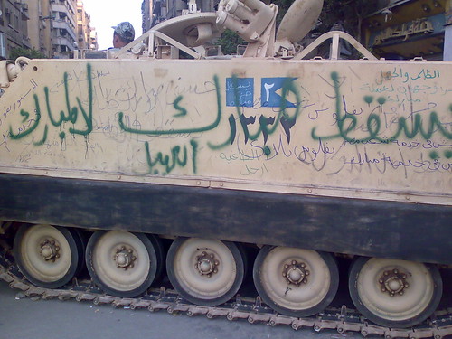
"... a carnival atmosphere descended on the square, where vendors offered food at discount prices and protesters posed for pictures in front of tanks scrawled with slogans like, '30 years of humiliation and poverty.'"That's from an online NY Times article from yesterday that's been getting continuously updated (and now no longer shows the original quote). The set of events that have to go down to bring about the kind of social unrest we're seeing in Egypt aren't trivial. People routinely toss around the idea of "revolution" when discussing topics like a change in US political party or new regulations (e.g., of gun control, carbon taxation, health care...) but the costs of revolution, in particular in terms of the uncertainty of its outcome, are huge. So I think it bears thinking about for a second:
"Usually, I'm doing theoretical stuff down in the weeds," said Hansen, a Seattle-area native and applied mathematician at the Naval Research Laboratory in Monterey, Calif. "This is the only project where I can actually show pictures of the impact," he said, projecting images of Somali boatmen armed with missile-launchers and automatic weapons.The quote is from an article in the Seattle Times about a presentation that Hansen gave at the American Meteorological Society meeting. The model is driven by the fact that most if not all modern piracy depends on small, fast boats that can evade long-distance detection and can outpace larger slower cargo ships. In heavy weather the boats can't operate. Combine weather forecasts with observed pirate activity and voilà.